Birmingham City Council
Tree preservation zone
There is a problem
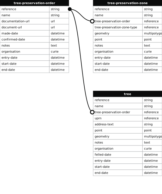
- 1000 entries with tree-preservation-order field must match the reference field in the tree preservation order dataset
THE BIRMINGHAM (LAND AT CORINNE CLOSE, RUBERY) TPO 1977
- reference
- 252
- name
- THE BIRMINGHAM (LAND AT CORINNE CLOSE, RUBERY) TPO 1977
- tree-preservation-order
- TPO 252
- tree-preservation-zone-type
- area
- geometry
- MULTIPOLYGON (((-2.010433 52.391297,-2.010448 52.391450,-2.010605 52.391527,-2.010604 52.391432,-2.010611 52.391341,-2.010622 52.391280,-2.010670 52.391078,-2.010679 52.391078,-2.010655 52.390897,-2.010651 52.390812,-2.010652 52.390798,-2.010671 52.390728,-2.010686 52.390681,-2.010686 52.390676,-2.010689 52.390667,-2.010707 52.390580,-2.010727 52.390524,-2.010856 52.390407,-2.010860 52.390394,-2.010912 52.390308,-2.010865 52.390025,-2.010789 52.389861,-2.010723 52.389867,-2.010726 52.389880,-2.010740 52.389983,-2.010509 52.390012,-2.010518 52.390046,-2.010529 52.390072,-2.010548 52.390128,-2.010608 52.390247,-2.010611 52.390264,-2.010553 52.390347,-2.010544 52.390390,-2.010528 52.390439,-2.010506 52.390484,-2.010493 52.390503,-2.010165 52.390544,-2.010199 52.390658,-2.010308 52.391059,-2.010367 52.391258,-2.010433 52.391297)))
- point
- POINT (-2.010554 52.390677)
- notes
- The shaded area represents those properties which fall within the outline of a Tree Preservation Order. To precisely identify trees protected by the Order, you can request a copy of the tree preservation order at the following link.
- entry-date
- 2026-10-14
- start-date
- end-date
How to fix this issue
Your data is missing a tree-preservation-order.
The tree preservation zone guidance explains how to fix the issue:
tree-preservation-order
The reference for the tree preservation order that covers this zone.
How to improve Birmingham City Council’s data
- Fix the errors indicated
- Use the check service to make sure the data meets the standard
- Publish the updated data on the endpoint URL